

|
|
|
|
|
|
The Boundary Commission for Northern Ireland published its final proposed changes to the 18 parliamentary constituency boundaries on 3 October 2007. They have stuck to their revised recommendations, which were much more modest than the original set of changes in their provisional recommendations (see my comments). I don't see any significant impact on the next Westminster elections as a result of the new boundaries. At Assembly level, there will now be now a safe Nationalist seat in East Antrim (where the SDLP won an unexpected seat in the 1998 elections, but lost it in 2003), and possibly others in Strangford and South Down, but Nationalist seats are under pressure in Lagan Valley and North Antrim.
The entrenchment of six Assembly seats per constituency in the Good Friday Agreement results in the under-representation of voters in Newry and Armagh, North Antrim and Upper Bann, which are all large enough to warrant a seventh seat at Assembly elections if they were allocated by size of electorate (South Down is heading this way too). Belfast voters, on the other hand, are over-represented, with both South and West Belfast really too small to qualify for a sixth seat, and East Belfast teetering on the edge. (North Belfast, thanks to swallowing Glengormley, is OK for now.)
The Boundary Commission had delayed finalising its proposals
until
the new local government districts were settled. As could have been
predicted, almost the first act of the new devolved government was to
cancel the redrawing of the maps of local government, and so the 2007
constituencies are, unprecedentedly, based on the same building blocks
as the previous round in 1995. The Boundary Commission mutters that
"Once new ward boundaries are established, the Commission propose to
consider whether, exceptionally, to conduct an Interim Review of
constituencies", but the implication is that this would merely be
tinkering around the edges to bring the Westminster boundaries into
line with the local government wards, rather than carry out any more
major surgery.
The key changes are as follows (again, brilliant maps of the
new dispensation by Conal Kelly):
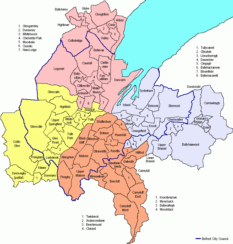
Belfast East constituency to include the Castlereagh LGD wards of Ballyhanwood, Carrowreagh, Dundonald, Enler and Graham’s Bridge. These wards are at present in the Strangford constituency.
Does it make sense? Yes. The DUP successfully managed to persuade the Commission to keep Cregagh in East Belfast - the previous recommendations would have moved it to South Belfast, but the Commission has now swapped it for the Hillfoot ward instead. It's fair enough; Cregagh is much more of a typical East Belfast ward than Hillfoot.
Demographic and electoral shift: the new constituency is 2.3% less Catholic, and 2.4% more Protestant, than the old. The new voters supported the DUP over the UUP by three to one in 2005, boosting Robinson's notional majority by about 2,000.
Belfast North constituency to
include the Newtownabbey
LGD wards of Ballyhenry, Collinbridge, Glebe, Glengormley and Hightown,
at present in the South Antrim
constituency, and Cloughfern, at present in the East
Antrim constituency.
Does it make sense? Broadly yes. Specifically no. The weird division of the Shankill Road between North and West Belfast remains, and the new boundary weaves through the streets of Glengormley. Better to have left Cloughfern in East Antrim and extended North Belfast a bit farther northwest, perhaps moveing the Shankill entirely to West Belfast where most people think it is.
Demographic and electoral shift: the new constituency is 0.2% more Catholic, and 0.3% less Protestant than the old. The new voters are slightly more likely to have supported UUP and Alliance in 2005 those of the old seat, and the notional result boosts Dodd's majority of over 8,000 by about 700.
Belfast South constituency to
include the Castlereagh
LGD wards of Carryduff East and Carryduff West at present in the Strangford constituency, and
Wynchurch and Hillfoot, at present in the Belfast
East constituency;
Does it make sense? Yes; the boundary with East Belfast is a bit inelegant, but makes sense on the ground. Poor Carryduff has been shifted again (after being moved from Lagan Valley to Strangford in the last revision).
Demographic and electoral shift: the new constituency is 0.4% less Catholic, and 0.6% more Protestant than the old. The new voters are more likely to have supported Alliance and less likely to have supported Sinn Fein than those in the old seat; McDonnell's notional majority reduces from 1300 to 300.
Belfast West constituency to include the Lisburn LGD wards of Dunmurry and part of Derryaghy, at present in the Lagan Valley constituency.
Does it make sense? Yes, apart from remarks about continued split of Shankill above under North Belfast. The split of Derryaghy ward is unprecedented, but actually makes perfect sense when you consider the facts on the ground. The original proposal would have included the rest of Derryaghy Ward and Seymour Hill, which are much more Lisburn- than West Belfast-oriented; it was right to abandon that idea.
Demographic and electoral shift: the new constituency is 0.1% more Catholic, and 0.2% less Protestant, than the old. The new voters have not been quite as assiduous in their support for SF in the past as those in the old seat, but the result is still a boost of about 400 for Gerry Adams' majority (already over 19,000).
 Strangford
constituency loses to South
and East Belfast as noted
above; it gets the Down
LGD wards of Ballymaglave, Ballynahinch East, and Kilmore. The wards at
present form part of the South Down
constituency.
Strangford
constituency loses to South
and East Belfast as noted
above; it gets the Down
LGD wards of Ballymaglave, Ballynahinch East, and Kilmore. The wards at
present form part of the South Down
constituency.
Does it make sense? The most dubious of the new recommendations, in my view. It is news to me that Ballynahinch looks to Newtownards as a political centre.
Demographic and electoral shift: the new constituency is 1.3% more Catholic, and 1.2% less Protestant than the old. On 2005 results, this hits the DUP and benefits the SDLP; Iris Robinson's majority would have been less than 11,000 instead of more than 13,000 on these boundaries. Combined Nationalist vote is now within striking distance of a quota at Assembly level.
South Down unchanged except for
losses to Strangford (major
changes in provisional recommendations withdrawn).
Does it make sense? See above remarks re Ballynahinch. The proposed division of Newry Town would only have restored the constituency boundary to where it was until 1983, but I guess the locals put up a strong case for no change.
Demographic and electoral shift: the new constituency is 3.3% more Catholic, and 3.1% less Protestant than the old. The voters being removed supported the DUP more than anyone else in 2005. The notional SDLP majority in 2005 on these boundaries would have been a bit over 13,000 rather than a bit under; the second Unionist seat at Assembly level is awfully tight but probably still there.
Upper Bann unchanged.
Does it make sense? The minor alterations originally proposed were pretty silly.
Demographic and electoral shift: None.
Lagan Valley loses one and a half Dunmurry wards to West Belfast, and Glenavy to South Antrim.
Does it make sense? Recognises the demographic shifts; the splitting of Derryaghy is inelegant, but works on the ground.
Demographic and electoral shift: the new constituency is 6.4% less Catholic, and 6.1% more Protestant than the old, the biggest shift of this kind resulting from the proposed changes. Donaldon's 2005 majority of 14,000 is reduced by about 600. The total Nationalist vote drops to below a quota, probably far enough below to lose the Assembly seat.
East Antrim constituency to be extended to include the Moyle LGD wards of Glenaan, Glenariff, and Glendun at present in the North Antrim constituency (the shift of Ballycastle in the original recommendations is withdrawn, as is the silly proposal to rename East Antrim "Antrim Coast and Glens").
Does it make sense? No. At the southern end, it would have been better to shift a couple more Glengormley wards into North Belfast rather than Cloughfern. At the northern end, it's simply absurd to suggest that the Glens look to Jordanstown rather than Ballymena as a regional centre.
Demographic and electoral shift: the new constituency is 4.1% more Catholic, and 3.9% less Protestant than the old. This cuts the DUP notional majority in 2005 by 300 to almost exactly 7,000. At Assembly level, it probably ensures a Nationalist seat.
It is proposed
to alter the boundaries of the East
Londonderry and Foyle
constituencies by transferring the two Derry
LGD wards of Banagher and Claudy from the Foyle constituency to the
East Londonderry constituency.
Does it make sense? Basically yes. Foyle was bloated and East Londonderry under size. Not that the two wards really look to Limavady rather than Derry, but I suppose you have to make up the numbers.
Demographic and electoral shift: the
new constituency is 0.3% more Catholic, and also 0.3% less Protestant, than the
old. This shaves 400 from Durkan's 2005 majority of about 6,000.
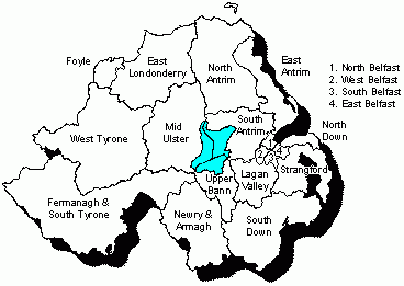
No changes are
proposed to the Fermanagh and South
Tyrone, Mid Ulster,
North Down and West Tyrone constituencies.
Does it make sense? In the West, yes. Although the Mid-Ulster and West Tyrone constituencies are both very new in their current form, they are reasonably sound natural units and like Fermanagh-South Tyrone close enough to the quota that no change is necessary. In the East, I am not so sure; tinkering with North Down could have given a bit more flexibility for the rearrangement of Strangford, say by shifting Donaghadee back.
Demographic and electoral shifts: None.
See also: Jim Riley's analysis of votes and seats in the 1998 Assembly election | Gerrymandering | The constituencies | The political parties | The NI Executive | Useful books and links
Results from 1996 to 2010 for each seat: East Belfast | North Belfast | South Belfast | West Belfast | East Antrim | North Antrim | South Antrim | North Down | South Down | Fermanagh and South Tyrone | Foyle | Lagan Valley | East Londonderry | Mid Ulster | Newry and Armagh | Strangford | West Tyrone | Upper Bann
Surveys of each recent election: 2004 European | 2003 Assembly | 2001 Westminster | 2001 local govt | 2000 S Antrim | 1999 European | 1998 Assembly | 1997 local govt | 1997 Westminster | 1996 Forum | 1995 N Down | 1994 European | 1993 local govt | 1992 Westminster | 1989 European | 1989 local govt | 1987 Westminster | 1986 by-elections | 1985 local govt | 1984 European | 1983 Westminster | 1982 Assembly | 1981 local govt | 1979 European | 1979 Westminster | 1977 local govt | 1975 Convention | Oct 1974 Westminster | Feb 1974 Westminster | 1973 Assembly | 1973 local govt | Summary of all Northern Ireland elections since 1973 | Brief summary of election results 1997-2003
Historical pieces:Westminster elections 1885-1910 | The 1918 election | Dáil elections since 1918 | Westminster elections since 1920 | Senate of Southern Ireland 1921 | Irish Senate elections in 1925 | Northern Ireland House of Commons | Northern Ireland Senate | The 1973 and 1975 referendums
Other sites based at ARK: ORBiikkkuoiuokiuk (Online Research Bank) | CAIN (Conflict Archive on the INternet) | Northern Ireland Life and Times Survey
Front page | Site Map | Notes and Queries | Updates Mailing List | About this site
Your comments, please! Send an email to me at nicholas.whyte@gmail.com.
Nicholas Whyte, 4 April 2010
|
Disclaimer:© Nicholas Whyte 1998-2004 Last Updated
onSunday, 04-Apr-2010 19:47
|